
Esta página en español
The earthquake in Ecuador has devastated many towns, cities and communities along the Pacific Coast. Ecuador as a whole has shown incredible solidarity with people on the ground working tirelessly to help each other, donation centres opening up all over the country and households being opened to the homeless. The international response has been impressive and aid continues to arrive to the affected areas.
Given today's technology there has been remote aid provided as well. Satellite imaging services such as Digital Globe and Planet Labs have been providing open imagery to support aid efforts. Mapping is crucial in a disaster affected area to improve logistics, help search and rescue efforts and to identify the areas most in need.
You can help remote mapping efforts by visiting either Tomnod (affiliated with Digital Globe) or through the Humanitarian Open Street Mapping site.
Additionally, anyone on the ground in Ecuador with an Android phone can contribute to data collection by following the directions below:
1 - Install the app called “ODK Collect” from Google Play store.

2 - Create an account with a username and password (optional).
3 – Open the app and go to “general settings”:

4 – Set “Platform” to ODK aggregate:

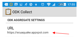
5 – Click on “Configure platform settings” and set to https://ecuaquake.appspot.com
6 – Go “back” to general settings and tick “Auto send with Wi-Fi”:

7- Go “back” to the “Main menu” and tap “Get Blank Form”:

8 – Select “Ecuador Earthquake” and tap “Get Selected”:

9 – You are now ready to collect data with an Android phone. To start collecting ensure your GPS (location) is turned on and select “Fill Blank Form” from the main menu in ODK Collect app.

This is very simple form to identify damaged buildings, impassable roads and areas of major destruction. It ties in with the data generated by Tomnod users.
Photos are optional.
It may take some time to get a fix on location.
Forms will automatically upload to the database when the phone is connected to Wi-Fi. Wi-Fi is not required for data collection.
Any data collected using the above method will be added to this map and freely available to anyone who will find it useful. Data collectors' identities will be kept anonymous.
If you enjoyed this post and would like to learn more about GIS or improve your skills check out our training courses. If you'd like to contribute a story, tutorial or anything else, please contact us.
Thanks for reading and if you'd like to support our content please feel free to buy us a coffee.